In 1883, Lincoln County was created from a portion of Spokane County, and four days later it, in turn, lost territory in the creation of Douglas County. Since that time there have been no changes in the boundaries of Lincoln County. When Lincoln County was established, Ferry County had not been created from Stevens County nor had Adams County been created from Whitman; and Lincoln County’s south-west, west and northern boundaries were defined as ”the mid-channel of the Columbia River; thence up said river in the middle of the channel thereof to the mouth of the Spokane River; thence up said Spokane River, in the middle of the channel thereof, to the place of beginning’. It is now bounded on the north by the counties of Stevens, Ferry and Okanogan; on the west by Grant county; on the south by Adams and Whitman Counties; and on the east by Spokane County. Comprising 2,317 square miles, it ranks eighth in size among the counties of the State.
Previous to the advent of white men, Lincoln County contained an Indian Trail extending from east to west. It was considered one of the most popular Indian thoroughfares in eastern Washington. The overnight camping place was the spring where now is located the town of Davenport. Bunch grass was abundant in the neighbourhood and the present site of Davenport was in the nature of an oasis.
One of the earliest recorded references to a now definitely known locality was that by Dave Thompson of the North-West Company of Montreal when, on July 3, 1811, he called Hell gate Rapid, a treacherous part of the Columbia River, 4 miles above the mouth of the San Poil River, ‘Strong Rapid’. Hell gate Rapids are now well ironed out because of the development of Grand Coulee Dam. The ‘Great Bend’, mentioned by Richard Arnold in 1853 in Pacific Railroad Reports, was the feature of the Columbia River, and the region about it now commonly called the ‘Big Bend’.
This Big Bend country lay to the north of the route of Lewis and Clark and was not traversed by them. The first white man here of whom we have any positive record, was David Thompson who descended the Columbia River from Kettle Falls to its mouth in 1811. For the next forty years fur traders frequently crossed over this country, and there was considerable travel overland. The Scotch botanist, David Douglas, after whom the Douglas fir is named, known to the Indians as the Grass man, traversed this section in 1826. The Rev. Samuel Parker of Ithaca, New York, a missionary explorer, was through the country in 1836. The Wilkes (U.S. Govt.) exploring expedition was also through here in 1841. Early missionaries included Catholic Fathers, F. N. Blanchet and Demers, who passed through here in 1838. Rev. Eells and Walker and their families camped near the site of Sprague in 1839. In 1853 part of a surveying company sent out by governor Stevens passed through and camped at various places within the present limits of the county.
As early as 1858 what is now Lincoln County was traversed by a party of miners on their way to the famous Fraser River mines. Hundreds of sanguine, stalwart men passed through the Territory of Washington and up the Okanogan River that year, to the newly discovered gold fields which, at that period, had created the wildest excitement, as did the Klondike country in the ’90s. There is substantial evidence that at least one party en route to the Fraser River made its way there via Lincoln County. A company of 350 men and several thousand head of stock left the Dalles, Oregon bound for Fraser River. They traveled from the Dalles to Walla Walla where government officials were then building the fort. Here the company employed an Indian to guide them to the mouth of the Okanogan River. The guide lost the trail and the mining party struck the Columbia opposite the mouth of the San Poil River. In due time they wound their way to the Fraser River, about thirty days out from the Dalles to the diggings.
Among the party who crossed the Big Bend plains in 1858 were J. R. Whitaker, who in 1881 returned to Lincoln County and settled on a ranch near Harrington, and Hiram F. Smith, better known in politics and mining circles as ‘Okanogan Smith’. Returning from the Fraser River country in 1860 Mr. Smith took up a ranch at the foot of Osoyoos Lake, in whit is now Okanogan County. Here he resided for many years and did much for the advancement of that northern country. In 1861 William Newman, after whom Newman’s Lake was named, came to the present site of Sprague. Here he became proprietor of a station for travelers and government express animals. At that early period Mr. Newman’s nearest neighbors were a lone settler at the mouth of the Palouse River, and Mr. James Monoghan. The latter came to this country in 1860 and established a ferry on the newly completed military road where it crossed the Spokane River, some twenty miles below the falls. Mr. Monoghan subsequently had charge of what was known as the LaPray bridge.
One of the first permanent settlers ‘ if not the first ‘ to locate in what afterwards became Lincoln County, was R. M. Bacon. Mr. Bacon left his home in Boston in 1860 and headed for the west. Three years later he came to the Colville valley, in Stevens county, where he remained until 1871. He then came to the Crab Creek country, in Lincoln County, and engaged in raising cattle. Except for an occasional band of Indians and the wild animals that ranged over the prairies, the entire country was a wild waste, destitute of life and denounced by military authority as a howling desert. Mr. Bacon confesses that he was a trifle lonesome the first year he spent in the Crab Creek country, but after that he was satisfied with his lot. He says that occasionally the Indians were a little ugly, but he was never molested, and did not think there was ever real cause for alarm. Within a few years after Mr. Bacon’s arrival in this part of the country, other hardy pioneers came and settled in his vicinity. In course of time a post office was established on Crab Creek know as the Crab Creek Post Office. Mr. Bacon became the first Postmaster in Lincoln County. Mail was received once a week by stage.
When the first settlers ventured out upon the broad bunch grass plains of Lincoln County and other parts of Central Washington, only the bottom lands along flowing creeks were considered of any value, and in such places these early pioneers sought to make themselves homes. For agricultural purposes the uplands were considered worthless; fit only for roving banks of cattle, horses and sheep. But a few years later, it was discovered that the uplands were better, and settlers who located upon them soon found that they were more eligibly situated than those who had preceded them and chosen homes on creek bottoms.
‘Wild Goose Bill’ (Samuel Wilbur Condit) might have justly claimed the honor of being the first actual white settler of Lincoln County as he claims his advent into this country as a settler where the town of Wilbur now stands in 1875. Wilbur, named for its founder in 1887, was incorporated in 1889. While out hunting Mr. Condit once mistook a settler’s poultry and shot a fat gander. Ever after he was known as ‘Wild Goose Bill’. Before he platted and named Wilbur, his trading place was known as ‘Goosetown’. He was a unique character. He engaged in all those various vocations typical of the frontiersman: stock raising, trading, freighting and ferrying. He took advantage of three Government land laws and located homestead, pre-emption, and timber culture claims on land now forming part of or contiguous to the present town of Wilbur. He also purchased forty acres of land from the Northern Pacific railroad and bought that pre-emption patent of one of his employees. These forty acres of railroad land formed the initial point of the original town of Wilbur. He owned Condin’s Ferry, Condin being his real name, but through a mistake his claim was made out to Condit.
‘Virginia Bill’ Covington was another well-known pioneer character and first settled near Brewster, at the mouth of the Okanogan, and ran a ferry there in 1865. In 1878 he located at the mouth of Hawk Creek, near Peach, and later had a saloon and dance hall at Fort Spokane. Matt Brislawn, a pioneer of ’78, settled on the Colville Road, seven miles north-east of Sprague in 1879.
The years 1877, 1878 and 1879 saw many settlers come to that part of the state to be later known as Lincoln County. Egypt was one of the earliest localities to attract the attention of the prospective settler. About 1880 two events occurred which hastened the settlement of the Lincoln County lands: the building of the Northern Pacific railroad and the establishment of Fort Spokane, which created demands for hay, grain and other commodities.
LOCATION OF COUNTY SEAT
In the act establishing Lincoln County, Davenport was made the temporary county seat. John Bartol, Edward D. Willis and John McGourin, named as the first county commissioners, convened at Davenport as provided by the act which created the county. Present with the commissioners was attorney S. C. Hyde. With the administration of the oaths of office they qualified and entered upon the discharge of their duties. Commissioner Bartol was elected chairman; and arrangements were made with Barney Fitzpatrick for the rent of a building, 24′ x 36′ in size, at $10 monthly rental, for the use of the county officers to be named by the commissioners.
The location of the permanent county seat caused some strife and led to amusing episodes during the early days of Lincoln County’s existence. When set apart from Spokane County, the town of Sprague had expected to have the county named Sprague and to become the county seat itself. When the name Lincoln was conferred upon the county and Davenport designated as the temporary county seat, a spirited contest was inevitable.
At the next general election, Davenport, Sprague, and Harrington entered the contest for the permanent county seat. The number of votes cast in both Davenport and Sprague was in excess of population. It was charged that children were voted as well as passengers on the through trains and names from tombstones in the cemeteries. Sprague seemed to have the advantage fo the railroad made the importation of votes easy, and every railroad man who could be spared came into town on election day, while Davenport had to transport its outside vote by horseback. Sprague showed the greatest number of votes and Davenport lost. The board of county commissioners was in session at 2:30 o’clock in the morning, November 12, 1884, and remained in session to receive reports from the canvassing board of election returns; and when it appeared to them that Sprague had received a majority of votes case for county seat, they resolved to adjourn to meet at Sprague at 2 o’clock in the afternoon of the same day and advised the county auditor to notify the county officers to remove their offices to Sprague as soon as convenient.
Charges of fraud were hurled at each other by the towns; citizens were arrested for illegal voting, but no convictions were secured. A building was leased for a courthouse and eventually the transfer of records was done though by force of arms.
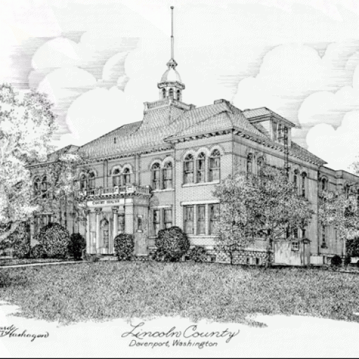
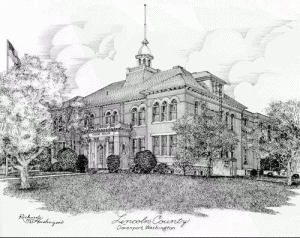
In 1890, another vote was taken on the location of the county seat, Davenport trying to retrieve its loss. Wilbur gave its strength to Sprague, and again Davenport was defeated. In 1896, the battle was renewed, and this time Davenport was victorious. The supporters of Davenport gave a block of land 215′ x 250′, where the courthouse now stands, and a bonus to replace the courthouse erected at Sprague. The returns of the election on the county seat gave 1,582 votes for the removal of county seat to Davenport, 240 for removal to Harrington, and 537 votes against removal from Sprague, and it was ordered by the board of county commissioners ‘that after 12 o’clock midnight on the 14th day of December A. D. 1896, Davenport, Washington is declared to be the county seat’. A courthouse was built at Davenport at a cost of $12,119, and the county buildings and lots located in Sprague were sold at public auction for $300, a poor compensation for the $10,000 Lincoln County had spent for them.
TOPOGRAPHY OF LINCOLN COUNTY
Nearly all of Lincoln County lies in the physiographic province termed by geologists as the channelled Scablands. More popularly, this region is called the Big Bend Plateau. The area essentially is a plateau, 1,500 to 2,500 feet in elevation with a system of channels or coulees eroded into bedrock by glacial rivers and streams of the recent ice age. These ancient rivers flowed from the north-eastern highlands of Washington in a south-westerly direction. Part of the early drainage of the upper Columbia watershed was carried through these channels during the ice age 20,000 or more years ago. Today these channels remain as the beds of smaller streams such as Wilson Creek, Crab Creek, Cow Creek and Lake Creek and some shallow water bodies such as Colville, Sylvan and Tue Lakes. The plateau surface and the tablelands between the channels are gently rolling with wide expanses of wind-deposited soil suited for grain farming. In places, such as west of Davenport, bed-rock or ‘scab rock’ is exposed at the surface. In northern Lincoln County the terrain is more elevated and is rougher where the Columbia River has cut a gorge across the plateau. This gorge is now occupied by Franklin Roosevelt Lake, the reservoir behind Grand Coulee Dam. In general, it can be termed a plains area dissected by a few shallow stream courses with many of its features modified since glacial times by a dry climate and wind erosion.
CLIMATE
Lincoln County has a semi-arid continental type of climate which is hot and dry in the summer and cold and moderately humid in the winter. Temperatures are quite uniform over most of the county because terrain does not vary more than 1,200 feet from the lowest to highest elevations. Precipitation varies from an arid condition in the western part of the county to semi-arid conditions in the north-east. The entire area lies in the dry intermontane basin between the Cascades and the Rocky Mountain System. Precipitation is a major controlling factor in agriculture. Most crop farming is in a zone of 10 to 20 inch annual precipitation near the reliability margin for growing wheat. Climatic conditions require adherence to a dry farming system of summer fallowing grain land and fall seeding to take advantage of maximum precipitation of the winter months. Precipitation in the Big Bend region is unreliable. Fluctuations in snow fall and rainfall, creating top soil moisture deficiencies have in the past caused failures or low yields of grain cops.
Annual precipitation ranges from 8 inches and less along the western line of Lincoln County to over 20 inches in the north-eastern corner. In general, the western two-thirds of the county has less than 16 inches of rainfall. Available data shows that Odessa is the driest station with about 10.58 inches per year. Davenport, in the north-east, has 16.48 inches. The summer season of June through September is dry, characterized by occasional local showers or hail storms. The winter is cloudy and moderately humid and most precipitation is received as snowfall. Winter rains and snow melt are absorbed by loam soils. By keeping the top soil stirred and loose through summer fallowing to lessen evaporation during hot summer days, a reserve of top soil moisture is accumulated for fall sown grains. A generally reliable snow cover of mid-winter also protects winter wheat and barley sprouts from freezing temperatures.
Monthly temperature averages range from below freezing in mid-winter to highs of about 65 to 71 degrees Fahrenheit in mid-summer. Records at Davenport, Odessa and Wilbur show that winter months are cold and summer months are hot. During December and January average temperatures range from 28 to 35 degrees while in July and August the range is from 66 to 71 degrees.
WHEAT FARMING
Lincoln County is the second most important wheat producing county in Washington and also ranked second in the United States in 1954. Throughout the county’s history the most important crop has been wheat. Grown on the dry lands of the Big Bend region, it was the first important commercial crop grown by the pioneer farmers. The summer-fallow, dry farming system is widely used in wheat growing. Some 895 farms reported 392,000 acres of cultivated summer fallow during 1954. Most of this was used in wheat farming. Winter wheat is sown in the fall to take advantage of winter moisture and protective snow cover. Heavier and more reliable yields are obtained through this system.
LIVESTOCK, DAIRYING AND POULTRY
Livestock, dairying and poultry are secondary activities in Lincoln County when compared with field crops. In 1954 Lincoln County had the third highest income in the state from crops ($6,275,000), but ranked twenty-first in income from livestock and livestock products ($2,398,000).
Raising beef cattle is the major type of livestock farming. The combined total of beef and dairy cattle reached a new high in 1956 with 46,000. Beef cattle number reached an all-time high of 43,400 head. At the same time, dairy cattle number continued at their all-time low of 3,100 head. The county ranked eighth in the state in number of cattle and calves sold.
LINCOLN COUNTY FLAG DESIGN
- The background color is aqua-blue, representing the blue that predominates our sky, in addition to the waters of the Columbia and Spokane rivers, which border our County to the North, as well as the many lakes and streams which grace our County.
- The bust of President Abraham Lincoln, the 16th president of the United States and after whom our County was named.
- A shaft of wheat, both on the left and right sides of President Lincoln’s bust, representing our County’s major industry and the fact it is recorded as the second largest white wheat-producing County in the nation.
- The number under the bust of Lincoln, representing the year our County was formed while Washington was still a territory.
- Lincoln County’s flag was developed by residents of the County. It was presented to the County Commissioners and the public at the County Courthouse in Davenport on November 10, 1986 The flag was made in conjunction with the Centennial celebration commemorating Washington Territory gaining statehood.